Quarley History
Quarley lies north of the neighbouring parish of Grateley . Whereas Grateley derives its name from the "great lea", Quarley derives its name from a quarter of the lea. The Manor of Quarley was held by Earl Harold before the Norman Conquest, but in the Domesday Book the manor was assigned to William the Conqueror. It has a manor house and a church which are mentioned in the Domesday Book.
The parish church of St. Michael dates from Saxon times.
A feature of St Michael's is
that three church bells are housed in a frame, with a roof over it, in the
churchyard.
The village hall was rebuilt and opened in 1987, due mainly to fund raising
efforts by the villagers. The school, which was built in 1817 for 36 pupils, is
now a private house and the children of the village go to Amport school.
The village used to have a public house, but this was destroyed by fire in the
late 1920s. The Marquis of Winchester, who then owned virtually the whole
village, gave the villagers a choice of a new pub or a water supply for the
village. The villagers chose the water supply, and an artesian well was dug,
with a water tower. Hence the villagers who wanted something stronger walked
across the fields to the Plough Inn at Grateley.
There is more detailed information in Hampshire County Council - Hampshire Treasures - Volume 8 - Pages 177 - 182 at www.hants.gov.uk/hampshiretreasures/vol08/page177.html.
Quarley Iron-Age Hill Fort
This ovoid fort in a prominent position, was built in several phases. First occupation was an enclosure surrounded by a simple timber palisade, this was later augmented by a 6½ feet (2m) high dump rampart and a wide ditch, 13 feet (4m) deep with a slight counterscarp. Entrances were located on the south-west and south-east, but for some reason, both the rampart and the south-east entrance were left unfinished. A number of late bronze age linear earthworks radiate out from the site, which were possibly used for cattle ranching.
Historic Village Maps
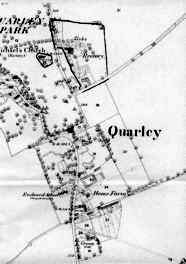 1870 village map |
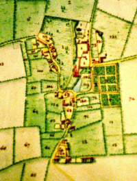 1803 Tithe map from Guildhall Library Ms 9773, archive of St. Katharine by the Tower. |
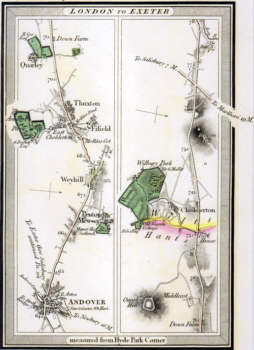 1817 High Roads, Edward Mogg |
You can click on the maps for larger versions - but they may take a little time to download.